Jackson Bentley: What is it, Major Lawrence, that attracts you personally to the desert?
T.E. Lawrence: It’s clean.
“Truly, for some men, nothing is written unless they write it.” — Sherif Ali
Message read on the bathroom wall
says, “I don’t feel at all like I fall”
And we’re losing all touch
losing all touch
building a desert
— Custom Concern, by Modest Mouse (1996)
Less Than a Quarter of the World’s Surface is Habitable
Deserts are intriguing features of our planet. Given that over 70.8% of our earth is covered in water, it’s hard to imagine an area with so little of it. However, knowing a bit more about how water is distributed on our planet helps. For example, over 96% of the water on earth is located in our vast and undrinkable oceans, which doesn’t leave a lot for the rest of the terrestrial planet.
Of the 29.2% of earthen terrain, it’s said that 17-33% is considered desert, depending on how strict a definition you’re using. Consider that mountains and beaches (neither of which are arable) comprise a lot of that, and suddenly 7.4 billion people is a lot of damn mouths to feed.
It certainly doesn’t help that most of the world’s fresh water is located in various inhospitable regions, like icy glaciers of Canada and Lake Baikal in a mountainous part of Siberia. Fortunately for the 60+ million people living in the Great Lakes megalopolis, the 94,000 square miles of their lakes alone contain 21% of the world’s drinking water. Unfortunately, the Rust Belt is doing a fantastic job of polluting the shit out of them.
But let’s dispense with crypto-apocalyptica for the moment, and get back to the topic.
Deserts
Knowing where water is distributed is also important in understanding deserts. Precipitation is the defining factor of a desert, since heat and sand are present in a lot of other places with plenty of rainfall. For example, I wouldn’t call Miami Beach a “desert,” even if it is devoid of civilized human beings.
Below is a world map showing average annual precipitation by country.
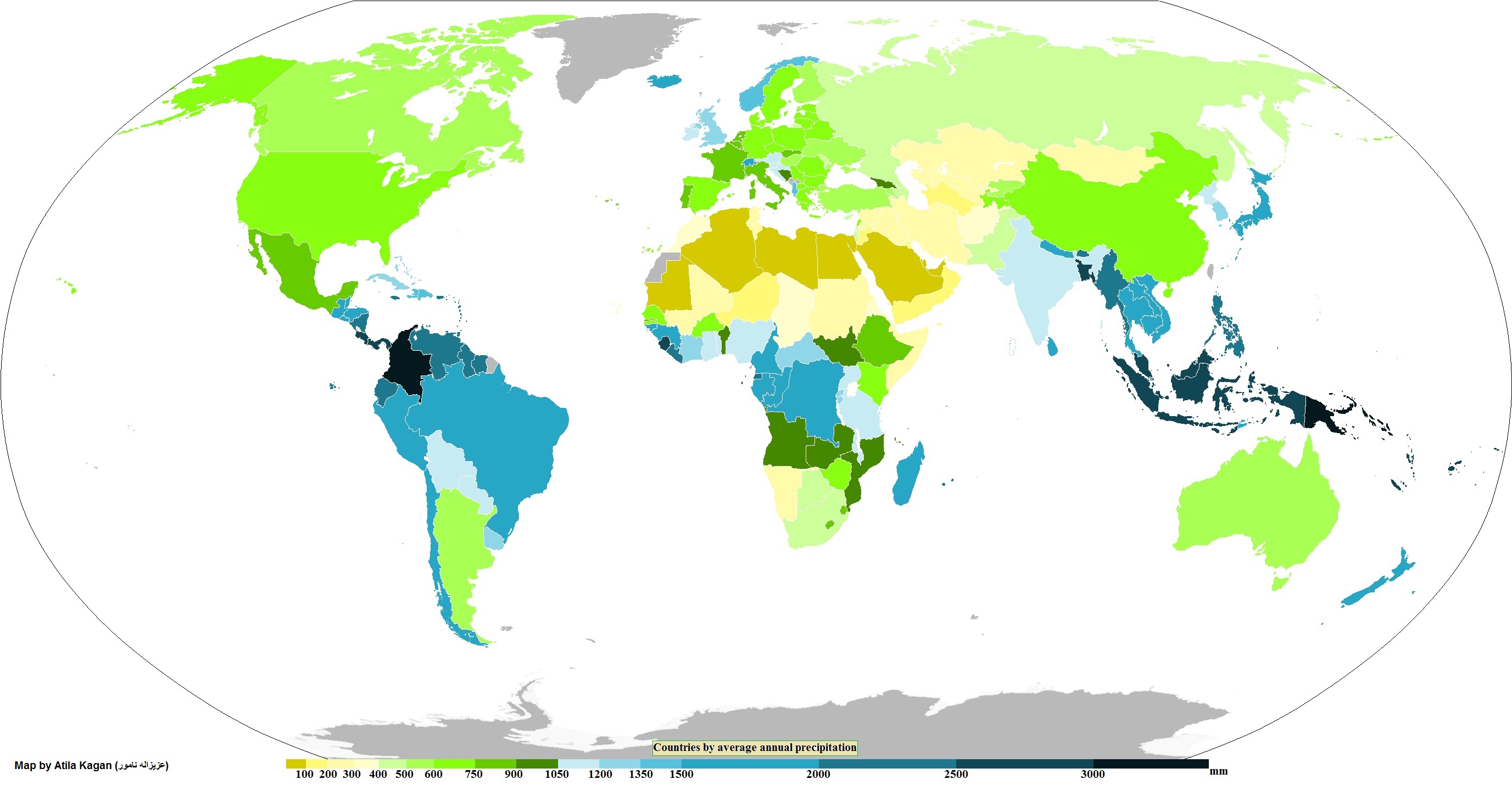
If any latitudinal trends emerged from the map above, hopefully it was the clustering of wet climates near the equator and drier climates near the tropics of Cancer and Capricorn. In fact, the mountainous regions of Columbia and Indonesia are some of the rainiest places on the planet, yet they’re only about 20 degrees of latitude from some of the harshest deserts.
I edited the above map to show where the world’s deserts are, compared to the major latitudinal lines.
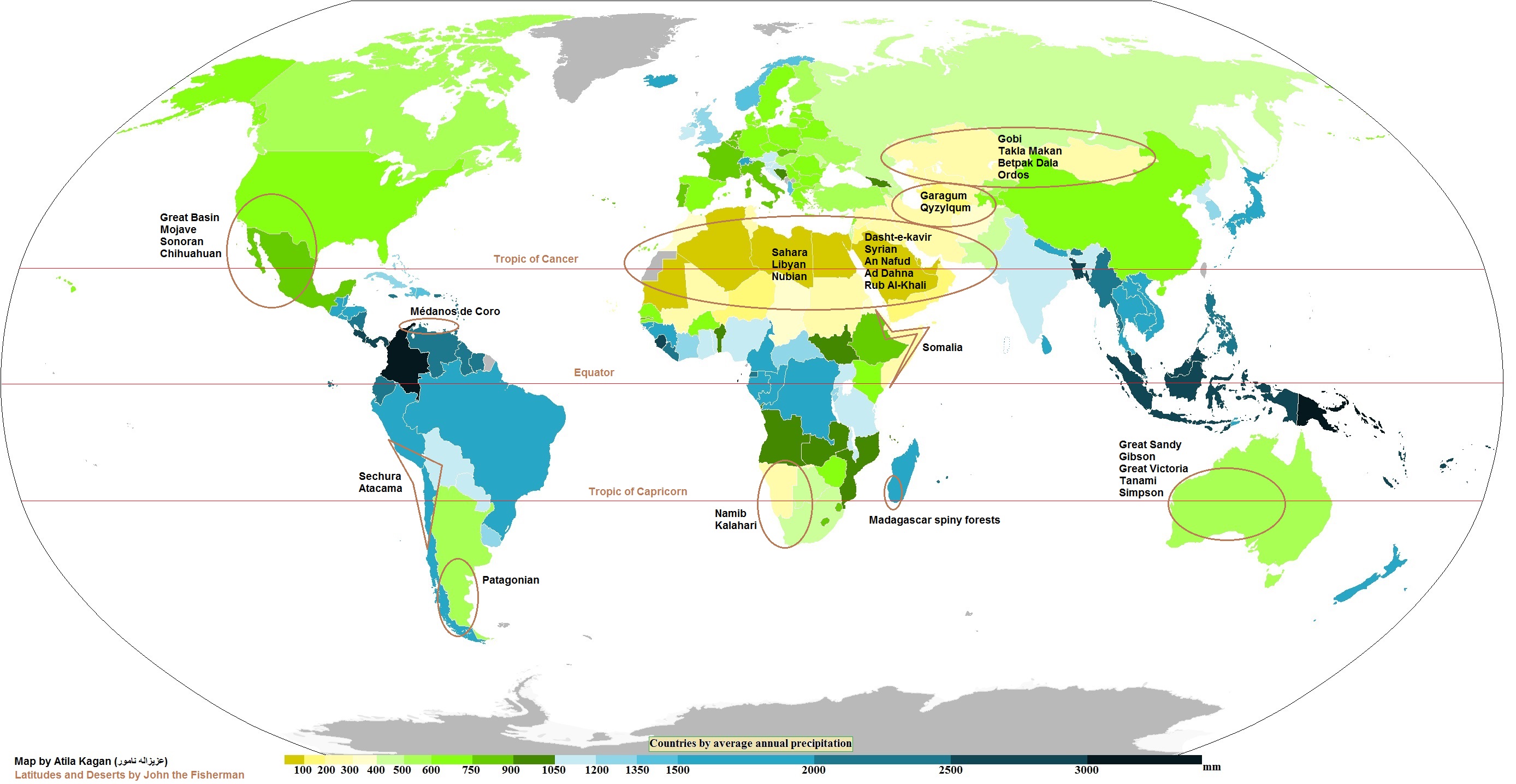
I’m surely missing some deserts on there, but these are the most notable ones. See how they align to the Tropics? The science here is simple and fascinating.
Hadley Cells (Equator to Tropics)
At the equator, solar rays hit the earth’s surface at perpendicular angles (i.e. direct). This causes the equatorial surface (which is mostly ocean water) to heat up. The warm and moist air at the surface ascends, and is replaced by inrushing air known as “trade winds” from north and south of the equator. These winds are actually the final part of a circular process we’re beginning here at the equator, but more on that later. Focus on the rising air.
As the warm air continues to ascend into higher altitudes, it cools. This now high, cold air has a lower saturation point, and it can’t hold all the moisture it did near the surface. The moisture condenses until the cool air can’t hold it anymore, and eventually falls as equatorial precipitation. This process created the world’s most famous rain forests in the Amazon, Congo, and Indonesia.
After precipitation falls, the air continues to rise and cool. At a certain temperature, it descends and heats up again. It arrives back on the surface as warm, dry air at the Horse latitudes, which are just outside the Tropics. The descending, warm, dry air also creates a “high-pressure system,” which suppresses precipitation and cloud formation. These subtropical highs at 30-40 degrees latitude created the world’s most famous deserts.
This aeronomic journey, from warm equatorial ascension to high-pressure descent at the Horse latitudes (and back again), is part of what’s known as a Hadley Cell. There are two of them, one north and one south of equator, and they both wrap all the way around the globe.
Ferrel and Polar Cells (Tropics to polar circles)
Atmospheric circulation doesn’t end at the Horse latitudes. Ferrel Cells (also called mid-latitude cells) continue atmospheric circulation north and south of the equator toward the poles, and Polar Cells continue the process into the arctic and antarctic circles.
Technically, only Hadley and Polar Cells are closed loops. The strong heat source of the former and the strong cold sink of the latter drive convection, and allow those circulation systems to create their own weather and maintain prevailing wind patterns (trade winds and polar easterlies, respectively). On the other hand, Ferrel Cells are in an awkward middle ground with no convection engine, and its prevailing winds (westerlies) get disrupted by passing weather systems all the time.
While interesting, these weather patterns only matter to our desert conversation in the following way: When Ferrel Cells do operate normally, they amplify Polar Cell desertification near the poles. For instance, I didn’t include Antarctica in the map above, but it is technically a desert since it only gets 6.5 inches of precipitation a year. The same goes for the northern latitudes, which include the cold, dry climes of northern Russia and Scandinavia, and the smallest desert in the world, in Yukon (Carcross Desert).
A West Coast Thing?
Clearly, latitudinal atmospheric circulation is a huge driving force behind where deserts form, especially when you’re looking at a map from north to south.
However, what got me interested in writing on deserts was that I noticed how many are located on the western sides of land masses. Most of the major deserts on every continent are located on their western side, and only two of the deserts in my map above are on eastern coasts (Patagonia and Somalia). It turns out that global circulation of ocean currents does affect desertification.
Gravitation from the sun and moon pulls air and water particles on the surface toward them. This creates a sort of delay in surface air and water movement relative to the Earth’s rotational movement, and this delay is greatest at the equator where centrifugal speeds are fastest. As the Earth turns west to east, ocean currents and winds flow from east to west, creating equatorial currents and easterlies/trade winds.
Equatorial currents behave similar to equatorial air particles in the process above. The main difference is that oceanic circulation moves east/west, while atmospheric circulation moves north/south. The warm/cold rotation of surface water in oceanic circulation is called “upwelling.”
Upwelling is when warm ocean water retreats westward, away from the continents. Cold, nutrient-rich waters then rush eastward to the shore, and up to the surface to replace the retreating warm water. Any wind blowing onshore will be doing so over these cold currents. If you’ll recall, cool winds have poor moisture-bearing capacity, and this leads to minimum evaporation and very low rainfall nearby. Thus, a coastal desert is formed on the western side of a land mass.
Such deserts include the Atacama on the west coast of South America, some regions of which have not had rainfall for over 400 years. One advantage these deserts have over inland deserts is that cool morning fogs can become common, so while they are some of the driest ecosystems on Earth, they do have a regular (albeit minute) deposit of moisture. The fogs are so reliable that a Canadian non-profit set up a series of fog collection units along the South American west coast to help secure drinking water for locals.
Another example of a west coast upwelling desert is the Namib Desert on the southwest coast of Africa, which is not only the sole ‘true desert’ in southern Africa, but possibly the oldest desert on Earth. The fogs here have proved disastrous to the shipping industry – a long stretch of shipwrecks here has been nicknamed “Skeleton Coast” – but the Namibian desert beetle has evolved a way to harvest tiny drops of water from the air and flourishes there. Baja California and the Atlantic coast of Morocco are also upwelling deserts.
Other Factors in Desertification?
Inland deserts like those in Asia might seem like outliers based on the information above. They’re not situated on or near Horse latitudes, nor are they on western coasts. Still, the formation of inland deserts is the simplest to describe and the most conceivable for laymen.
Because so much of the world’s water is found in oceans, any region located far from one risks desertification by default. As air moves inland, its moisture falls as precipitation, meaning by the time air makes its way deep to a continent’s interior it simply doesn’t have any moisture left.
The massive scale of the Sahara means that much of it is far removed from any water source. The late Ténéré Tree, in present day Niger, was once considered the most isolated tree on Earth. It was hundreds of miles from the nearest tree, and at least 1,000 miles from the nearest of three bodies of water. Sadly, it was knocked over by a drunk Libyan truck driver in 1973.
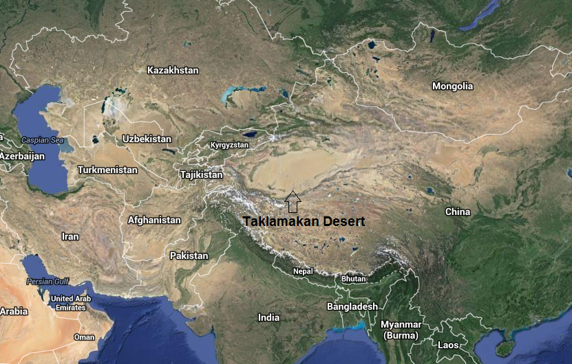
The Taklamakan Desert, which looks like a giant sand pit on the western edge of China, is also a long way from water. It is 1,200+ miles from the Bay of Bengal, 1,300+ miles from the Arabian Sea, and 2,000+ miles from the East China Sea. See below.
However, the Taklamakan Desert did not form solely because of its distance from water. In fact, this great beige spot might not exist without the Jammu and Kashmir stretch of the Himalayan Mountains, which steals all the moisture from passing clouds and sends it streaming back into the Indus River valley. This is known as the rainshadow effect.
The rainshadow effect occurs when moisture-laden air hits a mountain range. The air is pushed up, where it cools rapidly and dumps its precipitation on the windward side of the mountains. Once over the mountains, the air descends quickly and picks up moisture as it warms. This is why the leeward side of mountain ranges are so sunny and dry (e.g. Denver).
The size of the rainshadow is somewhat proportional to the size of the mountain range, and the Himalayan Mountains cast a gigantic shadow. This might explain why everything on the north side of the Himilayas (Tibetan Plateau and Xinjiang Province) is almost entirely desert, while the states on the east side of the Rocky Mountains are covered in arable land.
The rainshadow effect also created Patagonia, on the leeward side of the Andes Mountains. Below is an example of an upwelling desert and a rainshadow desert in the same corner of South America.

Notice how arid Chile looks near its border with Bolivia, then how green it appears farther south on the windward side of the Andes. Next, look at how lush Argentina looks on its northeastern border with the -guays compared to the craggy brown of its southeastern shore. It’s no surprise that Chile’s capital and largest city is located halfway between the two areas, and that Argentina’s largest cities and cattle farms are located in more fertile regions north of the Rio Negro.
Conclusion
The global regularity of Horse Latitude desertification suggests that high-pressure systems are responsible for a majority of the world’s desert surface area. The deserts within the Sahara, are all high-pressure deserts, as well as the arid regions in the Middle East and Australia. None of those are in rainshadows, and only Morocco, Baja, and the west coast of Australia can claim upwelling as being at least partially responsible for their coastal deserts.
After high-pressure, causes of desertification is basically a toss up between upwelling, inland distance from water, and rainshadow effect. The Gobi and Taklamakan are both under the Himalayan rainshadow, as are other notable deserts worldwide like Patagonia (shadowed by the Andes) and North America’s Great Basin and Chihuahuan Deserts (shadowed by the Sierras). Upwelling is to blame for Atacama and Namib.
Most of the Sahara is so far inland it would never get any moisture even if it weren’t sitting smack dab on the Tropic of Cancer. In fact, the Sahara has so many things going against it, it’s no wonder that it stretches all the way across North Africa. A Saharan city in Libya held the record for highest temperature at 58 Celsius (136 Farenheit) until the record was overturned in 2012 and given to Death Valley, USA for its slightly less hellish 56.7 Celsius. Incidentally, Death Valley lies in the rainshadow of the Sierra Nevada.
Follow us:
Share this: